Ertech’s Geospatial Solutions
Ertech's Geospatial team partnered with C.R.Kennedy to implement new software and equipment to overcome dredging challenges on a recent project in Onslow.
Ertech is always looking for ways to proactively apply new technologies to achieve greater efficiency on projects. Ertech’s Geospatial Solutions team is leading with their constant innovation and successful partnerships to find always a better way!
Recently Spatial Source connected with our Project Manager to understand and document the win-win solution implemented on the Onslow Boating precinct project where we needed to dredge about 100,000 tonnes of dirt from the creek, and most of it was done underwater.
The project in question was the construction of a new boating precinct for the town of Onslow, about 1,300 kilometres north of Perth. An existing boat ramp had become a bit rickety and would go underwater at high tide, so a new ramp was needed. The new facility will also have pens in which people can moor their boats, and from which diving tours and fishing charters can operate.
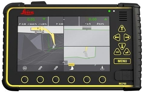
…“A lot of the dredging was done by operators who couldn’t even see where the bucket was,” added Saunders. “So they might be pulling out material that’s six, seven metres below the tracks, and all they’ve got to go off is the screen and where it’s saying the bucket is.”
Click here to continue reading: Leica Geosystems digs a dredging job out of a hole